Trails: Karekare Main car park – Karekare Road 100m – Watchmans Road 300m – Comans Track – Ahu Ahu Tack 100m – Mercer Bay Loop Walk – Te Ahua Point – Down hill to Mercer Bay beach – beach walk to Farley Point – Karekare beach – Karekare Main car park.
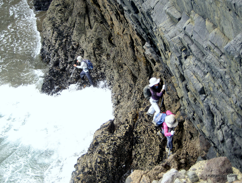
Caution: Experienced tramper only! Not recommended in winter or any wet weather and must be low tide. Do NOT try if you have acrophobia, or not good on rock climbing and swimming.
Car Park: Karekare Main Carpark for more than 20 cars. Set “-36.98621,174.47924” in your GPS. It’s bout 1 hour drive from Auckland city center.
Public Toilet: Yes.
Weather: Check Waitakere Weather before you go.
For better map display, click the buttons (Full Screen, Hide/Show Photos and Back to Center) in the top right corner of the map to study the tracks we took or any other tracks. For more information about Karekare, you may go to www.arc.govt.nz
Max elevation: 268 m
Min elevation: 10 m
Total climbing: 575 m
Total descent: -562 m
Average speed: 3.94 km/h
Total time: 04:08:09
Difficulty Rating: 1.95 – E
The “Total Time” is my time in March which includes morning tea time and lunch time. That day was fine and the track was good. If you slow down to average 2.5 km/h plus 75 min stop then the total time will be around 5 hrs.
Photos on the map. Click opened photo to close.


Click this photo below to see more amazing photos about this track!
Comans Track to Mercer Bay Loop Walk to Mercer Bay to Farley Point in Waitakere
Play this video to learn more about this track! Recommend 720+ HD for best quality video!
This really answered my drawback, thanks