Trails: Event base (private farmland) – Happy Valley loop (private farmland) – Lake Wainamu sand dune – Lake Wainamu Track – Te Henga Walkway – Goldie Bush Walkway to Mokoroa Stream Track loop – Te Henga Walkway – Lake Wainamu sand dune – Event base finish
Car Park: Yes at Private land. It’s about 35 km 40 minutes drive from Auckland city centre.
Public Toilet: Yes at Event Base
Weather: Check Weather before you go!
For better map display, click the buttons (Full Screen, Hide/Show Photos and Back to Center) in the top right corner of the map to study the tracks we took or any other tracks. For more information about these hiking tracks you may go to Waitakere Ranges.
Max elevation: 238 m
Min elevation: 10 m
Total climbing: 2588 m
Total descent: -2582 m
Average speed: 6.94 km/h
Total time: 07:15:50
Recorded total climbing: 1830 m. Moving time: 07:00:00 (not very accurate), Total flat distance: 42.6 km, Climbing distance: 16.4 km, Descent distance: 16.4 km, Flat distance: 10.4 km, Maximum difference: 229 m, Final balance: 0 m. Tracks were recorded by iphone 7 and corrected by ST3.
Difficulty Rating: H
The “Total Time” is my time in Dec. which includes drinking breaks. That day was fine and hot. Tracks were in good!

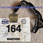
My second trail marathon finisher medal.
Derek
Could you give me some details about the Happy Valley track. Who would I have to ask for permission? We live on Wairere Road and often walk in the area.
Wynford
No idea whom should we talk to but what I know it’s all in private land.Private Land Map